Terrestrial Laser Scanning Market Size - Global Industry, Share, Analysis, Trends and Forecast 2023 - 2032
Published :
Report ID:
Pages :
Format :
Terrestrial Laser Scanning Market Size - Global Industry, Share, Analysis, Trends and Forecast 2023 - 2032
Report Coverage
- Industry Dynamics
- Market Size and Forecast Data
- Segment Analysis
- Competitive Landscape
- Regional Analysis with a Niche Focus on Country-Level Data
- High Level Analysis - Porter's, PESTEL, Value Chain, etc.
- Company Profiles of Key Players
- Option to Customize the Report As Per Your Specific Need
Request Sample Report
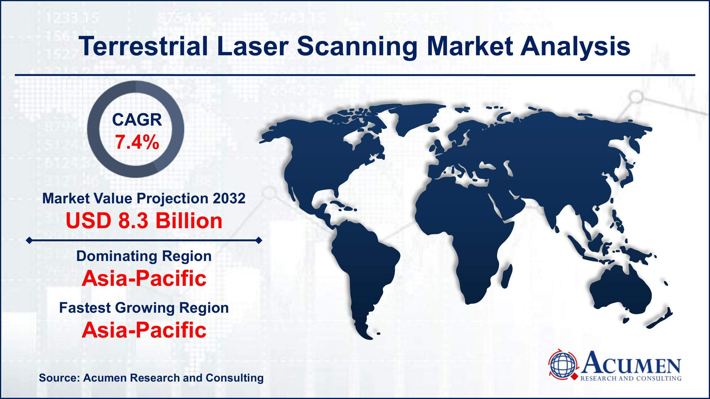
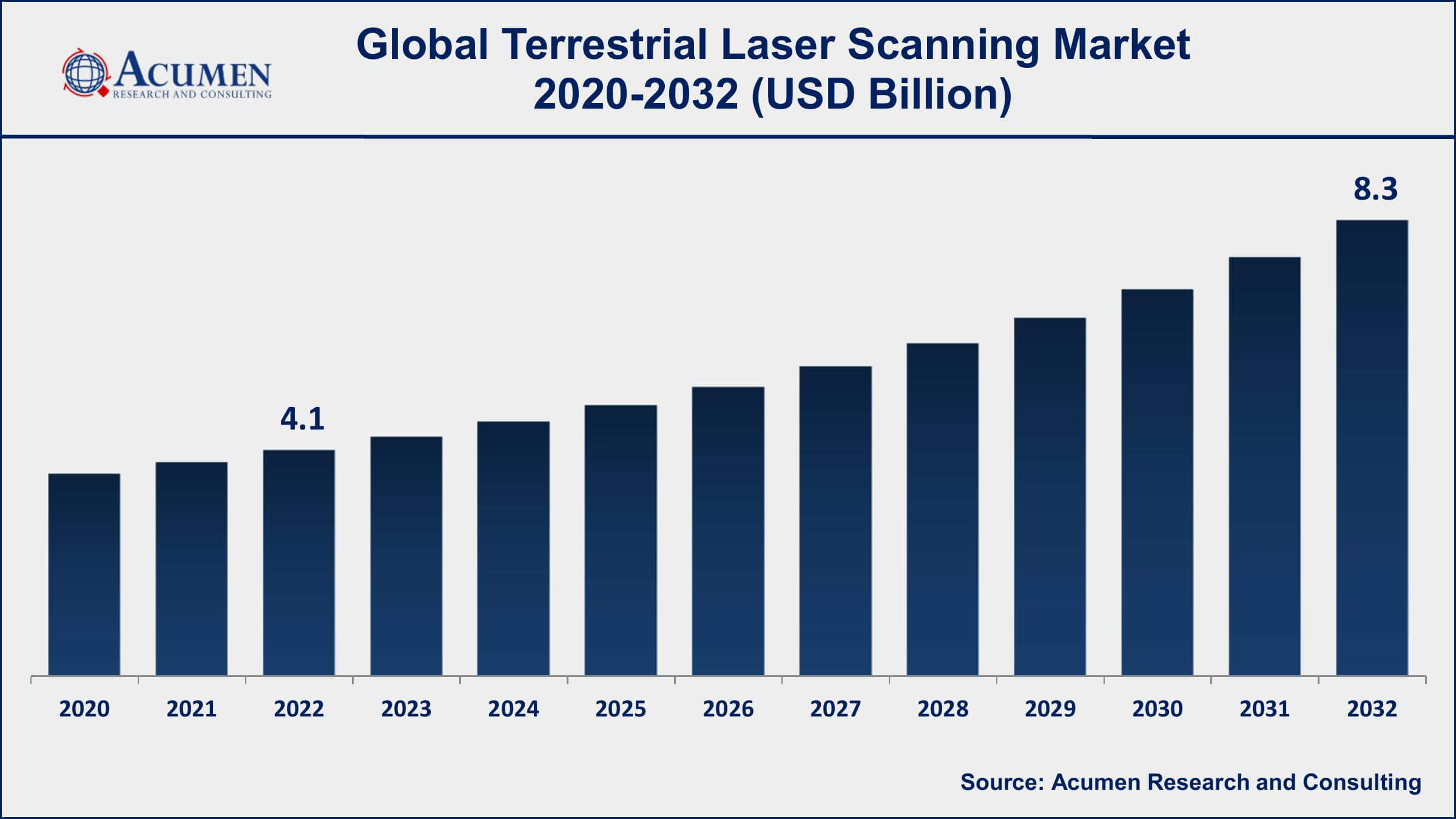
The Global Terrestrial Laser Scanning (TLS) Market Size accounted for USD 4.1 Billion in 2022 and is projected to achieve a market size of USD 8.3 Billion by 2032 growing at a CAGR of 7.4% from 2023 to 2032.
Terrestrial Laser Scanning Market Highlights
- Global terrestrial laser scanning market revenue is expected to increase by USD 8.3 Billion by 2032, with a 7.4% CAGR from 2023 to 2032
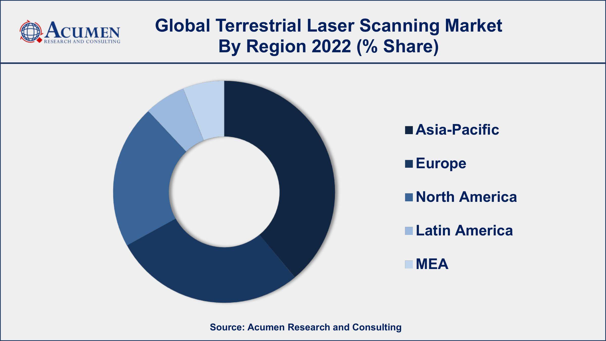
- Asia-Pacific region led with more than 38% of terrestrial laser scanning market share in 2022
- The construction industry is one of the largest users of TLS, accounting for a significant portion of the market share
- By solution, the scanning services segment has recorded more than 55% of the revenue share in 2022
- The forestry industry is a growing market for TLS, with a CAGR of 9% from 2023 to 2032
- Rising adoption of terrestrial laser scanning in the construction and infrastructure sectors, drives the terrestrial laser scanning market value

Terrestrial laser scanning is a surveying technique that uses laser beams to measure and create a three-dimensional representation of objects or environments. It works by emitting laser beams that bounce off surfaces and return to a scanner, which then creates a point cloud of data. This point cloud can be used to create detailed 3D models, maps, or visualizations of objects, buildings, and landscapes. Terrestrial laser scanning is used in various industries such as construction, architecture, engineering, and heritage preservation, to name a few.
The market growth of terrestrial laser scanning has been steadily increasing over the years, and it is expected to continue to do so in the coming years. The increasing demand for 3D modeling, mapping, and surveying technologies in various industries is a key driver for the growth of the market. Additionally, the advancements in scanning technology, such as the development of handheld and mobile scanners, are also contributing to the growth of the market. The rise in infrastructure development projects and government initiatives for digitization and smart city development is also expected to create more opportunities for the terrestrial laser scanning market growth.

Global Terrestrial Laser Scanning Market Trends
Market Drivers
- Growing demand for 3D modeling, mapping, and surveying technologies in various industries
- Advancements in scanning technology, such as handheld and mobile scanners
- Rising adoption of terrestrial laser scanning in the construction and infrastructure sectors
- Increasing government initiatives for smart city development and digitization
- Growing demand for accurate and reliable surveying solutions
Market Restraints
- High cost of terrestrial laser scanning systems and equipment
- Lack of skilled professionals to operate and manage the systems
Market Opportunities
- Increasing adoption of terrestrial laser scanning in the mining and oil and gas industries
- Growing demand for unmanned aerial vehicles (UAVs) for scanning applications
Terrestrial Laser Scanning Market Report Coverage
| Market | Terrestrial Laser Scanning Market |
| Terrestrial Laser Scanning Market Size 2022 | USD 4.1 Billion |
| Terrestrial Laser Scanning Market Forecast 2032 | USD 8.3 Billion |
| Terrestrial Laser Scanning Market CAGR During 2023 - 2032 | 7.4% |
| Terrestrial Laser Scanning Market Analysis Period | 2020 - 2032 |
| Terrestrial Laser Scanning Market Base Year | 2022 |
| Terrestrial Laser Scanning Market Forecast Data | 2023 - 2032 |
| Segments Covered | By Solution, By Technology, By Application, And By Geography |
| Regional Scope | North America, Europe, Asia Pacific, Latin America, and Middle East & Africa |
| Key Companies Profiled | Trimble Inc., Leica Geosystems AG, Faro Technologies Inc., RIEGL Laser Measurement Systems GmbH, Topcon Corporation, Zoller + Fröhlich GmbH, Teledyne Optech, Maptek Pty Ltd., Optech Inc., Velodyne Lidar, Inc., SICK AG, and Hexagon AB (Leica Geosystems division). |
| Report Coverage |
Market Trends, Drivers, Restraints, Competitive Analysis, Player Profiling, Covid-19 Analysis, Regulation Analysis |
Terrestrial laser scanning is a surveying technique that uses laser beams to measure and create a three-dimensional representation of objects or environments. It is a highly accurate and efficient way to gather spatial data, allowing for detailed 3D models, maps, or visualizations of objects, buildings, and landscapes. It works by emitting laser beams that bounce off surfaces and return to a scanner, which then creates a point cloud of data. Terrestrial laser scanning has a wide range of applications in various industries such as construction, architecture, engineering, and heritage preservation. In the construction industry, it is used for site planning, monitoring, and quality control, as well as for creating as-built models of buildings and infrastructure. In architecture, it is used to create detailed 3D models of buildings, facades, and interiors for design and renovation purposes. In engineering, it is used for structural analysis, deformation monitoring, and asset management. In heritage preservation, it is used to create 3D models of historical buildings and artifacts, helping to preserve them for future generations.
The terrestrial laser scanning market has been growing steadily over the years and is expected to continue its growth trajectory in the coming years. The demand for 3D modeling, mapping, and surveying technologies in various industries is one of the key drivers for the growth of the market. In addition, the advancements in scanning technology, such as handheld and mobile scanners, are also contributing to the growth of the market. The construction and infrastructure sectors have been the major adopters of terrestrial laser scanning, and this trend is expected to continue in the coming years. The rising adoption of Building Information Modelling (BIM) and the need for accurate and reliable surveying solutions are also driving the growth of the market. Furthermore, the increasing government initiatives for smart city development and digitization are expected to create more opportunities for the growth of the terrestrial laser scanning market.
Terrestrial Laser Scanning Market Segmentation
The global terrestrial laser scanning market segmentation is based on solution, technology, application, and geography.
Terrestrial Laser Scanning Market By Solution
- Scanning Systems
- Scanning Services
According to the terrestrial laser scanning industry analysis, the scanning services segment accounted for the largest market share in 2022. This segment includes various service providers that offer scanning services for 3D modeling, mapping, surveying, and other applications. The scanning services segment has been growing steadily over the years and is expected to continue its growth trajectory in the coming years. The demand for scanning services is being driven by the growing need for accurate and reliable surveying solutions in various industries. Service providers are offering a range of scanning services, including site surveying, laser scanning, point cloud processing, and data visualization. The adoption of Building Information Modelling (BIM) and other digital solutions in the construction and infrastructure sectors has also created more opportunities for scanning service providers.
Terrestrial Laser Scanning Market By Technology
- Phase Shift Scanning
- Mobile Scanning
- Pulse based Scanning
In terms of technologies, the phase shift scanning segment is expected to witness significant growth in the coming years. The demand for phase shift scanning is being driven by the need for accurate and reliable surveying solutions in various industries. Phase shift scanners offer a higher level of accuracy and precision compared to other scanning technologies, such as time-of-flight and triangulation scanners. This makes them particularly suitable for applications that require high levels of accuracy, such as industrial metrology and aerospace. Furthermore, the advancements in phase shift scanning technology, such as the development of handheld and mobile scanners, are also contributing to the growth of the segment. Handheld and mobile scanners offer greater flexibility and convenience for scanning applications and are being increasingly used in industries such as mining, oil and gas, and forestry.
Terrestrial Laser Scanning Market By Application
- Building Information Modeling
- Forestry and Agricultural Survey
- Topographical Survey
- Mining Survey
- Research and Engineering
- Construction Survey
- Others
According to the terrestrial laser scanning market forecast, the building information modeling (BIM) segment is expected to witness significant growth in the coming years. BIM is a digital representation of a building or infrastructure project that enables designers, architects, and contractors to visualize and simulate the project before it is constructed. BIM integrates 3D scanning, modeling, and simulation technologies, and offers a range of benefits, such as improved collaboration, reduced errors and rework, and better project management. The demand for BIM is being driven by the growing adoption of digital solutions in the construction and infrastructure sectors. BIM is being increasingly used by architects, engineers, and contractors to plan and design projects, and to improve project outcomes.
Terrestrial Laser Scanning Market Regional Outlook
North America
- U.S.
- Canada
Europe
- U.K.
- Germany
- France
- Spain
- Rest of Europe
Asia-Pacific
- India
- Japan
- China
- Australia
- South Korea
- Rest of Asia-Pacific
Latin America
- Brazil
- Mexico
- Rest of Latin America
The Middle East & Africa
- South Africa
- GCC Countries
- Rest of the Middle East & Africa (ME&A)

Terrestrial Laser Scanning Market Regional Analysis
The Asia-Pacific region is dominating the terrestrial laser scanning market and is expected to continue its growth trajectory in the coming years. There are several factors that are driving the growth of the market in this region. One of the key factors is the growing demand for infrastructure development in emerging economies, such as China and India. The use of terrestrial laser scanning is becoming increasingly popular in these countries, as it offers a cost-effective and efficient way to capture accurate and detailed information about infrastructure projects. Furthermore, the increasing adoption of Building Information Modelling (BIM) in the construction and infrastructure sectors is also contributing to the growth of the terrestrial laser scanning market in the region. BIM is being used extensively in the region, as a way to improve construction quality and safety, and to reduce project delays and cost overruns. The integration of terrestrial laser scanning with BIM is creating more opportunities for the growth of the market in the region.
Terrestrial Laser Scanning Market Player
Some of the top terrestrial laser scanning market companies offered in the professional report include Trimble Inc., Leica Geosystems AG, Faro Technologies Inc., RIEGL Laser Measurement Systems GmbH, Topcon Corporation, Zoller + Fröhlich GmbH, Teledyne Optech, Maptek Pty Ltd., Optech Inc., Velodyne Lidar, Inc., SICK AG, and Hexagon AB (Leica Geosystems division).
Frequently Asked Questions
What was the market size of the global terrestrial laser scanning in 2022?
The market size of terrestrial laser scanning was USD 4.1 Billion in 2022.
What is the CAGR of the global terrestrial laser scanning market from 2023 to 2032?
The CAGR of terrestrial laser scanning is 7.4% during the analysis period of 2023 to 2032.
Which are the key players in the terrestrial laser scanning market?
The key players operating in the global market are including Trimble Inc., Leica Geosystems AG, Faro Technologies Inc., RIEGL Laser Measurement Systems GmbH, Topcon Corporation, Zoller + Fr�hlich GmbH, Teledyne Optech, Maptek Pty Ltd., Optech Inc., Velodyne Lidar, Inc., SICK AG, and Hexagon AB (Leica Geosystems division).
Which region dominated the global terrestrial laser scanning market share?
Asia-Pacific held the dominating position in terrestrial laser scanning industry during the analysis period of 2023 to 2032.
Which region registered fastest CAGR from 2023 to 2032?
Asia-Pacific region exhibited fastest growing CAGR for market of terrestrial laser scanning during the analysis period of 2023 to 2032.
What are the current trends and dynamics in the global terrestrial laser scanning industry?
The current trends and dynamics in the terrestrial laser scanning industry include growing demand for 3D modeling, mapping, and surveying technologies in various industries, and rising adoption of terrestrial laser scanning in the construction and infrastructure sectors.
Which technology held the maximum share in 2022?
The phase shift scanning technology held the maximum share of the terrestrial laser scanning industry.


