Aerial Imagery Market Size - Global Industry, Share, Analysis, Trends and Forecast 2023 - 2032
Published :
Report ID:
Pages :
Format :
Aerial Imagery Market Size - Global Industry, Share, Analysis, Trends and Forecast 2023 - 2032
Report Coverage
- Industry Dynamics
- Market Size and Forecast Data
- Segment Analysis
- Competitive Landscape
- Regional Analysis with a Niche Focus on Country-Level Data
- High Level Analysis - Porter's, PESTEL, Value Chain, etc.
- Company Profiles of Key Players
- Option to Customize the Report As Per Your Specific Need
Request Sample Report
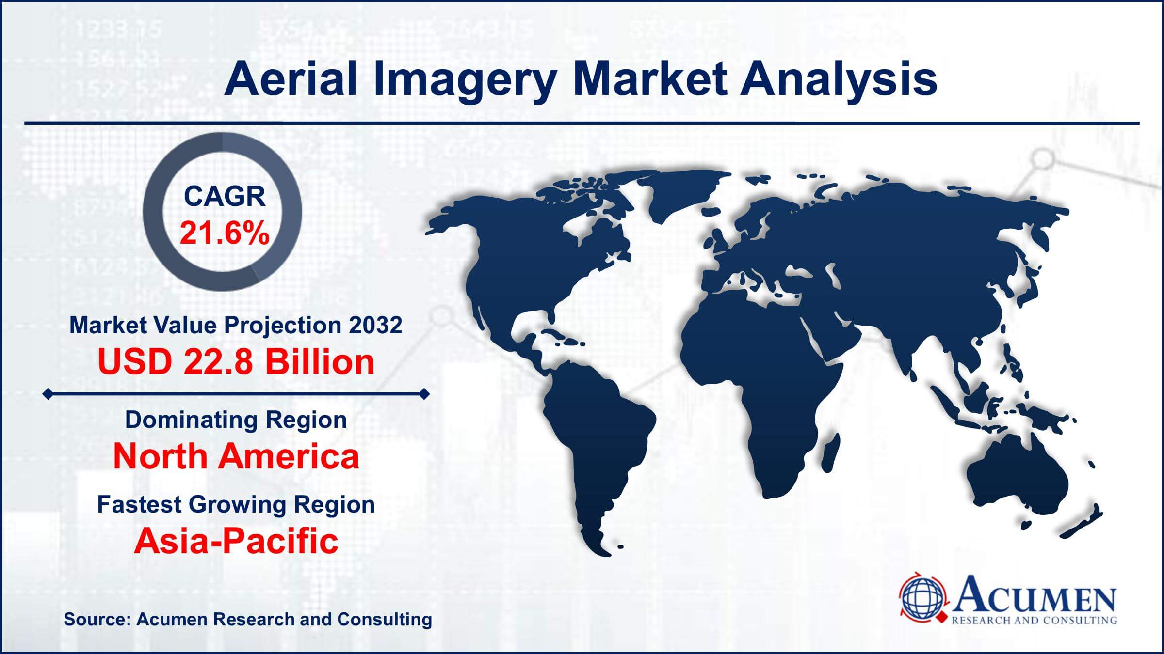
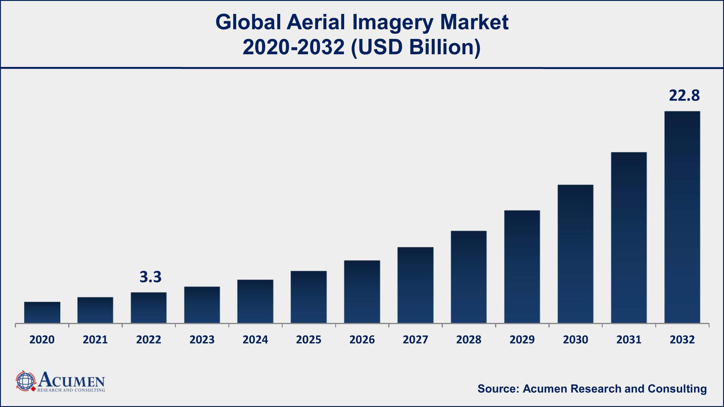
The Global Aerial Imagery Market Size accounted for USD 3.3 Billion in 2022 and is projected to achieve a market size of USD 22.8 Billion by 2032 growing at a CAGR of 21.6% from 2023 to 2032.
Aerial Imagery Market Report Key Highlights
- Global Aerial Imagery market revenue is expected to increase by USD 22.8 Billion by 2032, with a 21.6% CAGR from 2023 to 2032
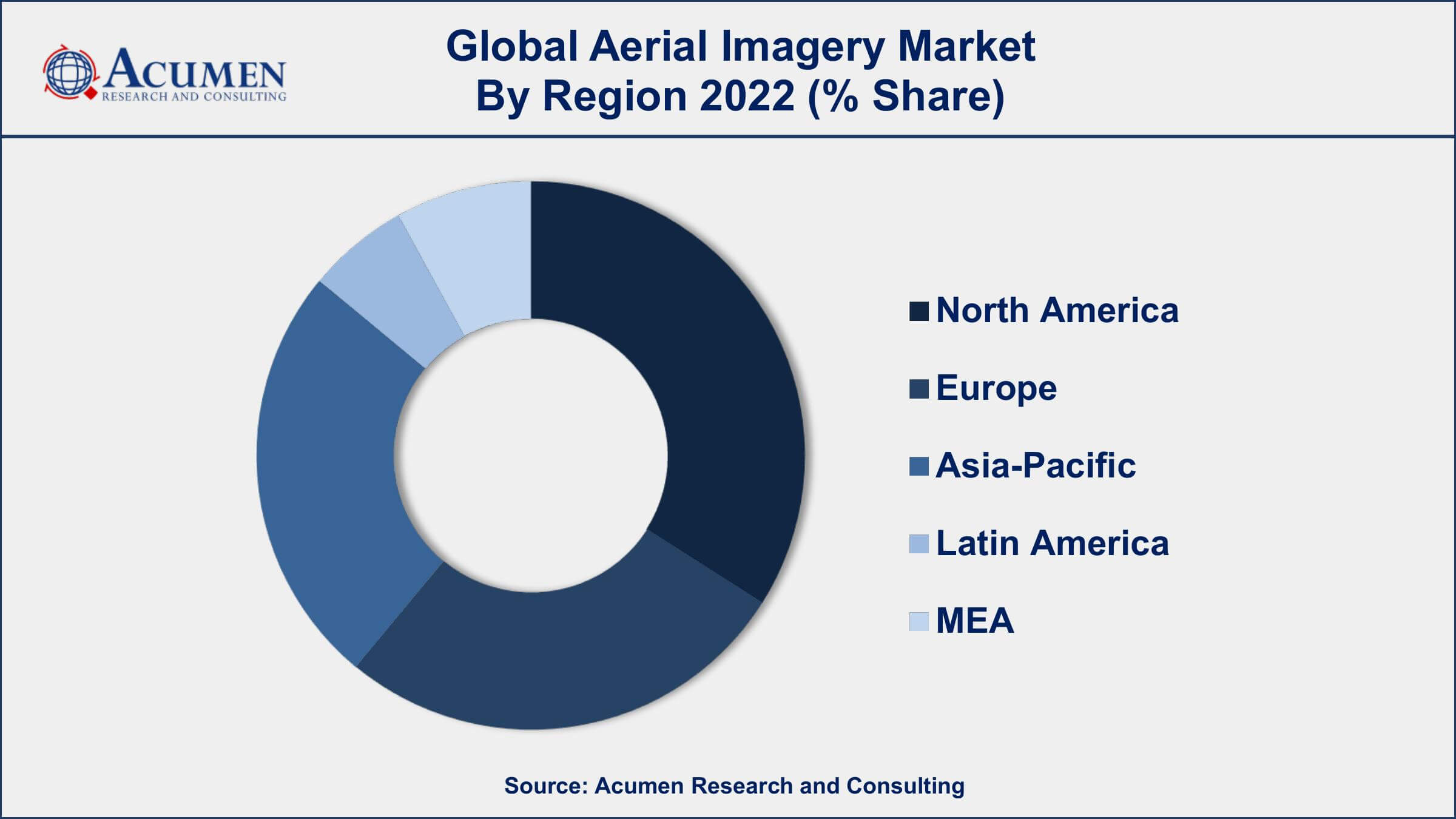
- North America region led with more than 34% of Aerial Imagery market share in 2022
- In 2019, the global market for drones in surveying and mapping was valued at $4.5 billion
- The agricultural sector is the largest user of aerial imagery, accounting for more than 30% of the total market share
- In the United States, the Federal Aviation Administration estimates that there will be around 7 million drones in operation by 2020
- In real estate, homes with aerial imagery sell 68% faster than those without
- Rising demand for location-based services and GIS mapping applications, drives the aerial imagery market size
Aerial imagery refers to photographs or images of the Earth's surface that are taken from an elevated perspective, typically from an airplane, helicopter, or drone. These images are often used in various fields such as cartography, urban planning, environmental monitoring, and agriculture. In the context of growth, aerial imagery can be used to monitor changes in land use, vegetation, and infrastructure over time. For example, satellite imagery can be used to track changes in agricultural land, such as the expansion of crops or the clearing of forests. Aerial imagery can also be used to monitor changes in urban areas, such as the growth of buildings, roads, and other infrastructure.
A personal aerial mapping system is an extraordinarily computerized aerial mapping system, generally used for aerial surveys and mapping. The aerial mapping system lets non-experts collect on-demand aerial images and thus produce highly detailed orthophotograph mosaics and digital models at low costs as compared to traditional procedures. The use of aerial drones rather than manned helicopters to minimize the overall cost is anticipated to be a key growth factor, thus influencing the growth of the global aerial imagery market. Also, the agriculture sector gets help by using drone technology, with applications in drainage planning and farmland management. The aerial imaging market serves several industries such as energy, agriculture, government, military & defense, civil engineering, and commercial, etc. Governments of various economies are focusing on the development of aerial imagery technologies which are anticipated to drive the market.
Global Aerial Imagery Market Trends
Market Drivers
- Increasing demand for aerial imagery in various industries such as agriculture, construction, and defense
- Advancements in technology such as drones, satellites, and LiDAR, which provide high-resolution and accurate aerial imagery
- Growing investments in infrastructure development and urban planning projects
- Rising demand for location-based services and GIS mapping applications
Market Restraints
- Stringent regulations and restrictions on commercial drone operations in certain regions
- Limited availability of skilled professionals for drone operations and data analysis
Market Opportunities
- Increasing demand for real-time aerial imagery and video for surveillance and monitoring purposes
- Growing use of artificial intelligence and machine learning algorithms for processing and analyzing aerial imagery data
Aerial Imagery Market Report Coverage
| Market | Aerial Imagery Market |
| Aerial Imagery Market Size 2022 | USD 3.3 Billion |
| Aerial Imagery Market Forecast 2032 | USD 5,582 Billion |
| Aerial Imagery Market CAGR During 2023 - 2032 | 21.6% |
| Aerial Imagery Market Analysis Period | 2020 - 2032 |
| Aerial Imagery Market Base Year | 2022 |
| Aerial Imagery Market Forecast Data | 2023 - 2032 |
| Segments Covered | By Platform Type, By Application, By End-user Industry, And By Geography |
| Regional Scope | North America, Europe, Asia Pacific, Latin America, and Middle East & Africa |
| Key Companies Profiled | Blom Norway AS, Fugro, Digital Aerial Solutions, LLC, Nearmap Ltd., Terra Flight Aerial Imaging Inc., Eagle View Technologies, Inc., Aerial Imaging Productions, LLC, Cooper Aerial Surveys Co., Global UAV Technologies Ltd, Kucera International, Landiscor, and Nearmap Ltd. |
| Report Coverage |
Market Trends, Drivers, Restraints, Competitive Analysis, Player Profiling, Covid-19 Analysis, Regulation Analysis |
Governments use aerial imagery technology for several purposes including homeland security, urban planning, monitoring environmental studies and energy management, etc. In addition, forestry and agriculture as well as other commercial applications are some major aspects expected to grow at a significant rate throughout the forecast period. Some of the few agricultural applications of aerial imagery mechanisms include scheduling and evaluation of pesticides & fertilizers, creating manageable zones, soil sampling, etc. Aerial imaging is used in commercial applications for advertising, construction progress evaluation & promotions. Furthermore, the increasing use of aerial imaging in resource management and construction is anticipated to drive the global aerial imagery market growth over the forecast period.
Land use calculation, road planning, and proving reference for the ground crew are some other uses of aerial imagery techniques for civil engineering applications, whereas energy applications involve logistics and drilling activities. The aerial imagery technique provides a key source of data & information for forecasting, managing, monitoring, and studying natural resources and human activities. Procurement of aerial images from diverse intervals is a helpful way to conduct research on the history of any area or authenticate different uses of land. Aerial photography or aerial imagery is the process of capturing photographs of the earth’s surface from a relatively raised position wherein the camera is not managed by a ground-based structure. Helicopters, stand-alone telescoping, balloons, fixed-wing aircraft, rockets, kites, vehicle-mounted poles, pigeons, parachutes, and multicolor unmanned aircraft systems are some of the various platforms used for aerial imagery technology. The cameras usually mounted for capturing aerial images can be triggered easily and remotely/automatically, whereas handheld photographs can be clicked by a photographer.
Efficient demand for aerial imagery systems, especially from the agriculture and forestry segment, is expected to act as the prime growth driver in the global aerial imagery market value. Also, demand from government organizations and agencies adopting aerial imagery technologies for research and development purposes are also a key element propelling the growth of the global aerial imagery market over the forecast period. However, operational inhibitions and concerns regarding security are some of the key challenges, in the global aerial imagery market. The security issue related to the usage of drones as autonomous flying robots is another vital aspect hampering the growth of the global aerial imagery market.
Aerial Imagery Market Segmentation
The global aerial imagery market segmentation is based on platform type, application, end-user industry, and geography.
Aerial Imagery Market By Platform Type
- Fixed-wing Aircraft
- UAVs/Drones
- Helicopters
- Others
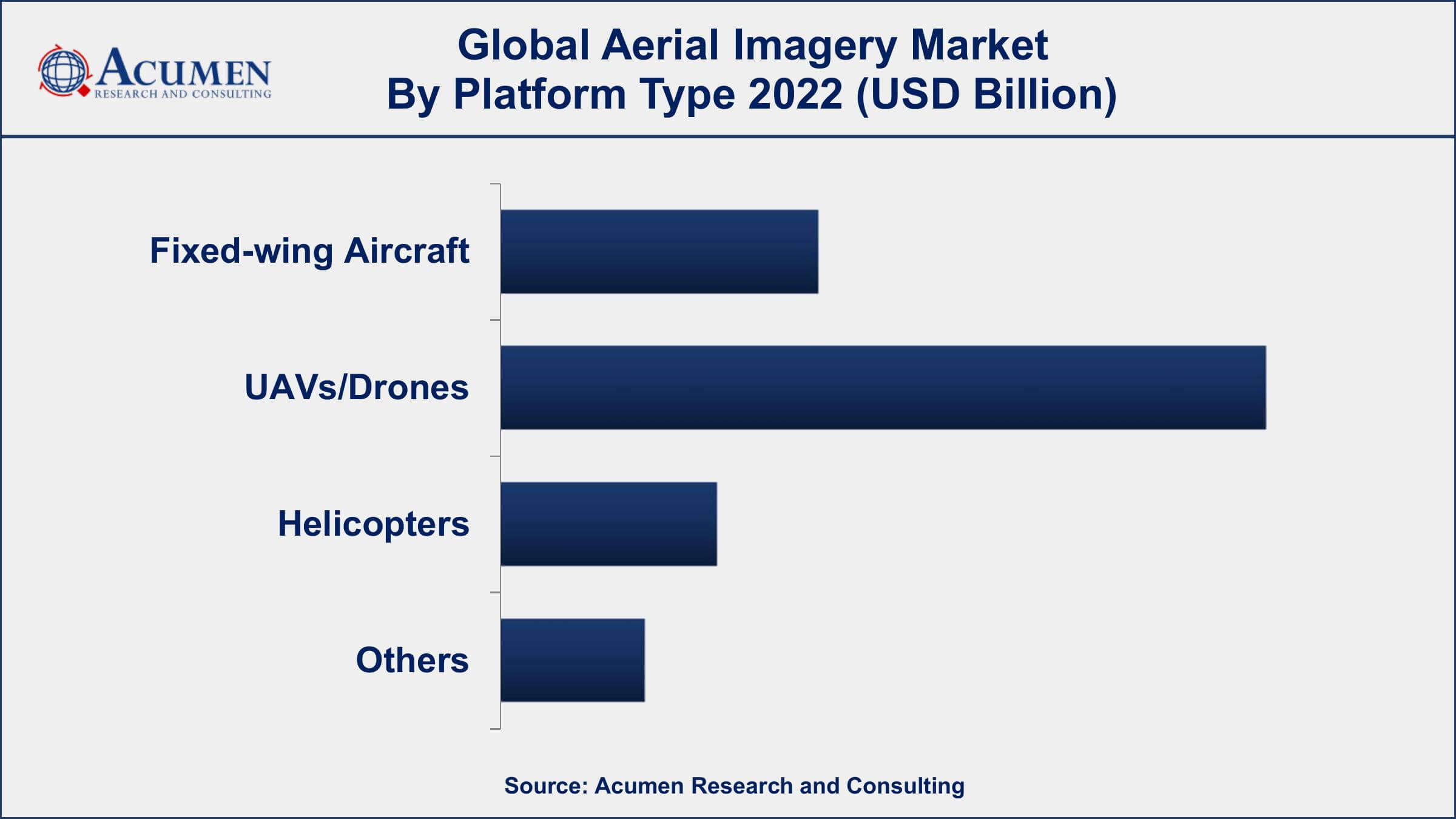
According to aerial imagery industry analysis, the UAVs/Drones segment accounted for the majority of market share in 2022. Drones equipped with cameras and sensors provide high-resolution and accurate aerial imagery, which is used for mapping, surveying, monitoring, and inspection purposes. The use of drones for aerial imagery is particularly beneficial in areas where access is difficult or dangerous, such as in disaster zones or in industrial sites. The use of drones for aerial imagery has several advantages, including cost savings and improved safety. Drones can capture images and data in real time, reducing the time and cost associated with traditional aerial surveys. Drones can also access hard-to-reach areas, reducing the need for manual inspections and increasing safety. Additionally, the development of new technologies such as LiDAR and multispectral imaging is expected to further enhance the capabilities of drones for aerial imaging.
Aerial Imagery Market By Application
- Infrastructure Planning
- Geospatial Mapping
- Environmental Monitoring
- Asset Inventory Management
- Surveillance and Monitoring
- National and Urban Mapping
- Disaster Management
- Others
In terms of application, the geospatial mapping application is a major segment of the overall market. Geospatial mapping refers to the use of aerial imagery to create accurate maps of the Earth's surface. Aerial imagery provides high-resolution and accurate data on land features such as topography, elevation, and vegetation, which is used to create detailed maps for various applications. The market for aerial imagery in geospatial mapping is driven by the increasing demand for accurate and detailed maps for various industries such as agriculture, construction, and infrastructure development. Aerial imagery is particularly useful in areas where access is difficult or dangerous, such as in mountainous regions or in remote areas.
Aerial Imagery Market By End-user Industry
- Construction
- Government
- Aerospace and Defense
- Energy and Power
- Agriculture
- Oil and Gas
- Other
According to the aerial imagery market forecast, the agriculture and government segments are expected to rise significantly in the coming years. Aerial imagery provides valuable data for monitoring and managing land use in agriculture and for government planning and management purposes. In agriculture, aerial imagery is used for crop monitoring, yield prediction, and soil analysis. High-resolution aerial imagery provides farmers with detailed information on crop health, growth patterns, and irrigation requirements, allowing for more efficient use of resources and increased yields. In government, aerial imagery is used for a variety of applications such as land use planning, disaster management, and infrastructure development. Aerial imagery provides accurate data on topography, land cover, and land use, which is used for mapping, modeling, and analysis purposes.
Aerial Imagery Market Regional Outlook
North America
- U.S.
- Canada
Europe
- U.K.
- Germany
- France
- Spain
- Rest of Europe
Asia-Pacific
- India
- Japan
- China
- Australia
- South Korea
- Rest of Asia-Pacific
Latin America
- Brazil
- Mexico
- Rest of Latin America
The Middle East & Africa
- South Africa
- GCC Countries
- Rest of the Middle East & Africa (ME&A)
Aerial Imagery Market Regional Analysis
North America is dominating the aerial imagery market due to several factors. The region is home to a large number of aerial imagery service providers and technology companies that are driving innovation in the industry. Additionally, North America has a highly developed infrastructure and a high level of technological expertise, which makes it an ideal market for aerial imagery.
Furthermore, North America is home to several key industries that use aerial imagery extensively, including agriculture, construction, and defense. The agriculture industry in North America is highly developed and relies on aerial imagery for crop monitoring and yield prediction. The construction industry in North America is also a significant market for aerial imagery, with drones and other technologies being used for site inspections and monitoring. Finally, the defense industry in North America uses aerial imagery for surveillance and monitoring purposes.
Aerial Imagery Market Player
Some of the top aerial imagery market companies offered in the professional report include Blom Norway AS, Fugro, Digital Aerial Solutions, LLC, Nearmap Ltd., Terra Flight Aerial Imaging Inc., Eagle View Technologies, Inc., Aerial Imaging Productions, LLC, Cooper Aerial Surveys Co., Global UAV Technologies Ltd, Kucera International, Landiscor, and Nearmap Ltd.
Frequently Asked Questions
What was the market size of the global aerial imagery in 2022?
The market size of aerial imagery was USD 3.3 Billion in 2022.
What is the CAGR of the global aerial imagery market during forecast period of 2023 to 2032?
The CAGR of aerial imagery market is 21.6% during the analysis period of 2023 to 2032.
Which are the key players operating in the market?
The key players operating in the global aerial imagery market are Blom Norway AS, Fugro, Digital Aerial Solutions, LLC, Nearmap Ltd., Terra Flight Aerial Imaging Inc., Eagle View Technologies, Inc., Aerial Imaging Productions, LLC, Cooper Aerial Surveys Co., Global UAV Technologies Ltd, Kucera International, Landiscor, and Nearmap Ltd.
Which region held the dominating position in the global aerial imagery market?
North America held the dominating position in aerial imagery market during the analysis period of 2023 to 2032.
Which region registered the fastest growing CAGR for the forecast period of 2023 to 2032?
Asia-Pacific region exhibited fastest growing CAGR for aerial imagery market during the analysis period of 2023 to 2032.
What are the current trends and dynamics in the global aerial imagery market?
The current trends and dynamics in the aerial imagery industry include the increasing demand for aerial imagery in various industries such as agriculture, construction, and defense.
Which platform type held the maximum share in 2022?
The UAVs/Drones platform type held the maximum share of the aerial imagery market.


